![]()
![]()
![]()
![]()
![]()

Slide 12
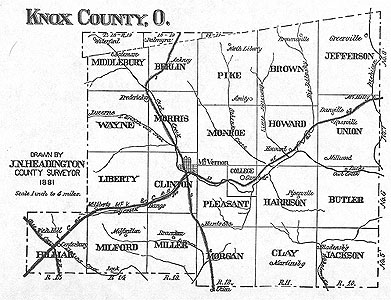
Map of Knox County, Ohio
The land, about 513 square miles, was rich and fertile. The topography included rolling hills and a river, called Owl Creek (now the Kokosing), which traversed the county.
|
|
Slide 12
The land, about 513 square miles, was rich and fertile. The topography included rolling hills and a river, called Owl Creek (now the Kokosing), which traversed the county. |
Slide
|
|
This website is best viewed in CSS- and DHTML-capable browsers (IE4 and Netscape 4, or later), with Javascript enabled. This site should function in older browsers, however some of the additional features may not work, and much of the layout will appear incorrect. If you can see this message, please visit http://www.microsoft.com or www.netscape.com to download a newer version of your favorite browser. The views and opinions expressed in this page are strictly those of the
information provider. The provider assumes full responsibility and liability
for the contents of this document. The contents of this page have neither been
reviewed nor approved by Kenyon College. All comments and feedback should be sent to
richmonda@kenyon.edu. This page and its
entire contents ©2001 Papers of Philander Chase, Andrew S. Richmond, Editor.
All rights reserved.
|